Note
Using GeoPandas with Rasterio to sample point data#
This example shows how to use GeoPandas with Rasterio. Rasterio is a package for reading and writing raster data.
In this example a set of vector points is used to sample raster data at those points.
The raster data used is Copernicus Sentinel data 2018 for Sentinel data.
[1]:
import geopandas
import rasterio
import matplotlib.pyplot as plt
from shapely.geometry import Point
Create example vector data#
Generate a geodataframe from a set of points
[2]:
# Create sampling points
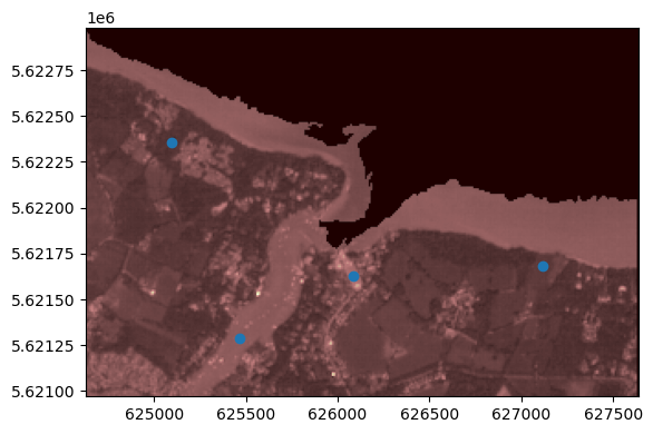
points = [Point(625466, 5621289), Point(626082, 5621627), Point(627116, 5621680), Point(625095, 5622358)]
gdf = geopandas.GeoDataFrame([1, 2, 3, 4], geometry=points, crs=32630)
The GeoDataFrame looks like this:
[3]:
gdf.head()
[3]:
| 0 | geometry | |
|---|---|---|
| 0 | 1 | POINT (625466.000 5621289.000) |
| 1 | 2 | POINT (626082.000 5621627.000) |
| 2 | 3 | POINT (627116.000 5621680.000) |
| 3 | 4 | POINT (625095.000 5622358.000) |
Open the raster data#
Use rasterio to open the raster data to be sampled
[4]:
src = rasterio.open('s2a_l2a_fishbourne.tif')
Let’s see the raster data with the point data overlaid.
[5]:
from rasterio.plot import show

fig, ax = plt.subplots()

# transform rasterio plot to real world coords
extent=[src.bounds[0], src.bounds[2], src.bounds[1], src.bounds[3]]
ax = rasterio.plot.show(src, extent=extent, ax=ax, cmap='pink')

gdf.plot(ax=ax)
[5]:
<AxesSubplot: >
Sampling the data#
Rasterio requires a list of the coordinates in x,y format rather than as the points that are in the geomentry column.
This can be achieved using the code below
[6]:
coord_list = [(x,y) for x,y in zip(gdf['geometry'].x , gdf['geometry'].y)]
Carry out the sampling of the data and store the results in a new column called value. Note that if the image has more than one band, a value is returned for each band.
[7]:
gdf['value'] = [x for x in src.sample(coord_list)]
gdf.head()
[7]:
| 0 | geometry | value | |
|---|---|---|---|
| 0 | 1 | POINT (625466.000 5621289.000) | [684.0, 1005.0, 707.0, 265.0] |
| 1 | 2 | POINT (626082.000 5621627.000) | [999.0, 1105.0, 1115.0, 1340.0] |
| 2 | 3 | POINT (627116.000 5621680.000) | [284.0, 713.0, 310.0, 5405.0] |
| 3 | 4 | POINT (625095.000 5622358.000) | [237.0, 564.0, 250.0, 3680.0] |